Why connectivity matters to wildlife—and people

What is ecological connectivity?

Ecological connectivity is the ability for animals on land or in water to move freely from place to place. Movement allows them to find food, breed, and establish new home territories. The unimpeded movement of animals and the flow of natural processes sustain life on Earth.

Why is connectivity important?

We’ve learned that protected areas in isolation aren’t enough. When protected areas are connected, they help maintain the natural processes that support clean air, rich soil, and freshwater on which we all rely. Habitats that allow for this unobstructed movement have what we call ‘high connectivity,’ meaning that all living things can freely move and access the resources they need to thrive. If connectivity is lost, landscapes, river systems, and seascapes become fragmented, the movement of wildlife becomes limited or ceases, and ecological systems can begin to break down.

Threats to connectivity

Development


Infrastructure


Agriculture


Climate


Energy


Overfishing


Deforestation


Development and infrastructure

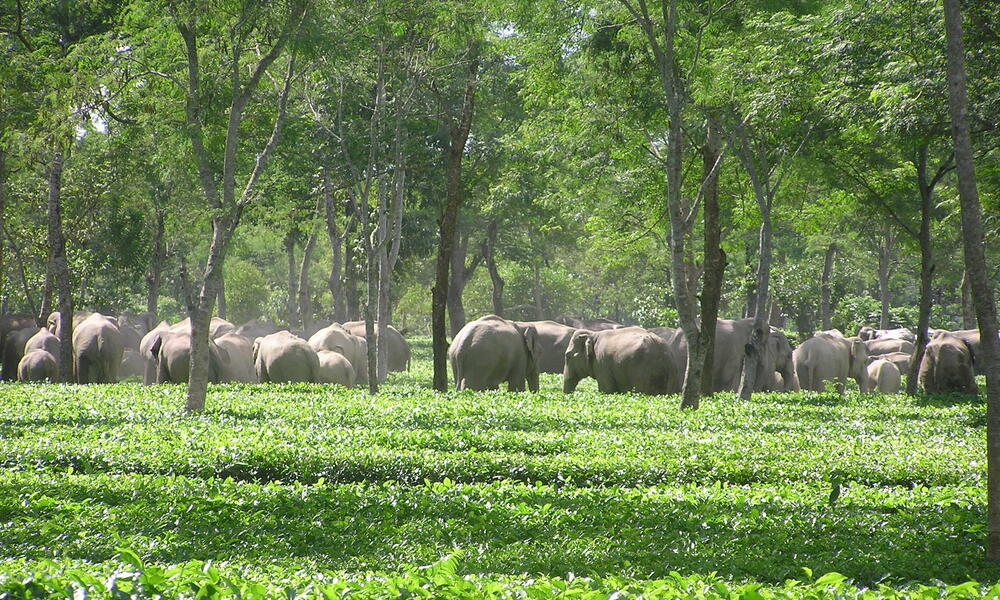
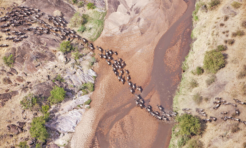
Unfortunately, human activity is disrupting ecological connectivity, often breaking up and degrading habitats in ways that are harmful to the animals that live in them. This can also lead to human-wildlife conflict as people and animals increasingly come into contact with each other as they compete for space and resources.

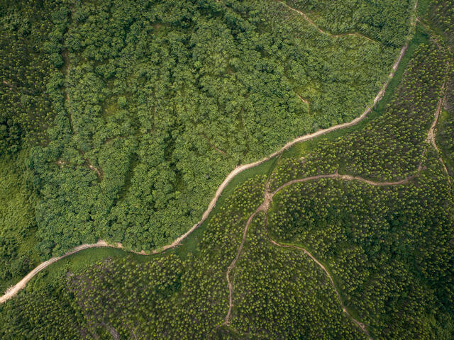
On land, a road or fence may prevent animals from accessing a water source. Expanding cities and towns can encroach on land once rich with wildlife, blocking their movement. In rivers, dams can prevent fish from swimming upstream to breed or find food. Similarly, offspring of marine species often travel great distances in the ocean between the nursery sites where they are born and feeding areas. These habitats can be connected by ocean currents, but when these routes are disrupted by activities such as overfishing or infrastructure development, offspring face difficulty reaching their destinations.

Fishing gear, shipping routes, and associated noise also negatively impact animals like whales that migrate vast distances in our oceans.

Climate crisis

The climate crisis, which is also caused by human activity, is contributing to increasing resource shortages, more frequent and extreme weather events, and rising and warming oceans. Because of these increasing threats, connectivity is more important than ever so that species can adapt and move away from places where conditions are becoming less favorable. Connectivity is crucial for the survival of wildlife amid the climate crisis.

For example, some wildlife may experience the drying up of water sources, shifting tree distributions, higher temperatures, and less prey. This could drive them from their current home in search of more suitable environments and resources. Without connectivity, the displaced wildlife will struggle to adapt to these changes.

Freshwater, food, and communities need connectivity too

Lack of connectivity doesn’t just impact the movements of animals but also disrupts the important ecological processes that people depend on for healthy natural resources and a rich array of life for their livelihoods.

For example, dams disrupt free-flowing rivers and impact downstream communities by altering seasonal flows of water that carry sediments and nutrients. These are necessary for healthy floodplain agriculture and fisheries and help reduce the risks from floods and droughts. Deforestation for agriculture and other land uses and forest degradation, due largely to illegal logging, are fragmenting important forest habitats. This means that forests are no longer able to perform the functions that help maintain healthy ecosystems, such as providing food, mitigating carbon emissions, reducing soil erosion, and maintaining healthy waterways. In Latin America, for example, more than half of the jaguar’s original range has been lost due to deforestation, agricultural expansion, and infrastructure development, isolating jaguar populations into individual pockets of land. Lack of connectivity among these habitats makes it difficult for jaguars to breed and seek prey, which increases human-wildlife conflict as jaguars turn to hunting livestock for food.

A herd of Asian elephants in a tea estate, North bank programme, India.

Restoring connectivity

WWF works to manage, maintain, and re-establish connectivity around the world, implementing various strategies depending on the type of landscape or seascape and species we’re working to conserve. On land and within rivers and the ocean, we maintain, create, and restore wildlife corridors—stretches of designated habitat that allow wildlife to move freely from one location to another. And WWF is increasingly working to maintain corridors in a way that is mindful of how climate impacts will affect plants and animals, enabling species and ecosystems to shift as conditions change. More generally, we support the management of lands, rivers, and the ocean to allow for wildlife movement in the ‘matrix’ between core protected areas. Wildlife can and do move through community lands, farms, ranches, and extractive concessions if they are designed and managed in ways that allow this.

AGRICULTURE

EXAMPLE: Sabah, Borneo
Studying elephants’ movements to establish and restore key wildlife corridors

Map showing Sabah region
  Protected areas      Elephant corridor

Sabah is a Malaysian state on the island of Borneo and home to endangered species, including Bornean elephants and orangutans. One of the greatest threats to these species is habitat loss and fragmentation from agricultural developments. In the past four decades, insufficient land use planning led to the loss of 60% of elephant habitat in Sabah to large-scale plantation development. Elephants now often occupy these plantations or move through them to reach adjacent forest reserves, leading to increased human-wildlife conflict.

It’s important to understand how species like elephants move through and use the landscape in order to reduce human-wildlife conflict and further elephant conservation. We attach GPS collars to elephants to collect data and track their movement. This helps us, in collaboration with government partners and plantation owners, to make informed decisions on where and how to establish protective barriers and wildlife corridors—stretches of natural habitat connecting populations of species otherwise separated by cultivated land, roads, and other barriers. We also support the management of protected areas and restoration of degraded forests and work with landowners, agricultural companies, and the local government to sustainably manage forests by promoting certification and improving the management effectiveness of these areas.

Plantation owners play a crucial role in restoring and maintaining corridors and landscape connectivity by ensuring that the installation of protective barriers (electric fences) is coordinated and does not hamper elephant movement. For example, elephants only eat oil palms aged seven years or less and some plantation owners are now switching from fencing their entire plantation, to only fencing areas with palm trees within this age range. Less fencing allows elephants to move through other areas of the concession, reducing human-elephant conflict.

CONSERVATION AREAS

We support governments and other partners to create and maintain large conservation areas that preserve intact habitats that allow wildlife to move within them unimpeded.

EXAMPLE: Kavango Zambezi Transfrontier Conservation Area (KAZA), Southern Africa
Maintaining and improving connectivity through identifying and protecting wildlife dispersal areas and empowering communities to manage their natural and cultural resources.

Map showing KAZA region
  Protected areas      KAZA boundary
  Key transboundary elephant movements

KAZA is the largest terrestrial transboundary conservation area in the world, spanning parts of five southern African countries—Angola, Botswana, Namibia, Zambia, and Zimbabwe. This landscape is one of Africa’s most intact and valuable conservation areas, home to a diversity of wildlife including the world’s largest population of elephants, and sustained by two of southern Africa’s most important freshwater systems, the Okavango and Zambezi Rivers. The KAZA landscape is extremely dry, and these rivers are vital to the migratory corridors, seasonal wildlife habitats, and to people and their livelihoods. Agricultural expansion, human settlements, and fences are breaking up this landscape and impacting wildlife movements and migrations. Dams in the headwaters of these basins are also a threat to water flows to downstream areas that act as a lifeline to wildlife in the region.

WWF scientists have helped identify six wildlife dispersal areas critical to the movement of wildlife across national borders, focusing on three in which wildlife populations and their habitats are secured and connected. These are key wildlife corridors identified based on existing and historical animal movement and migration routes. One way we’re doing this is by reducing the impact of fences, which particularly affect elephant movement, to help re-open wildlife migration routes. We’re working to encourage community-based conservation efforts of these wildlife dispersal areas to protect wildlife, promote tourism, help people and wildlife to adapt to climate change, and sustainably manage the region’s natural resources—ultimately supporting the socioeconomic well-being of local communities.

INFRASTRUCTURE

We also work with governments, industry, and communities on land-use planning to create infrastructure with the environment in mind, helping to assess the long-term risks and impacts to both wildlife and people from potential infrastructure development.

EXAMPLE: The Greater Mekong-Southeast Asia
Advocating for renewable energy like large-scale solar farms and sustainable hydropower development to help maintain the health and connectivity of the Mekong River

Map showing Mekong River
  Mekong River

The Greater Mekong spans five countries: Myanmar, Lao PDR, Thailand, Cambodia, and Vietnam. At the heart of this region flows the Mekong River, stretching 2,610 miles from China at its source to Vietnam’s Mekong delta. It’s one of the most biodiverse river systems in the world, second only to the Amazon. And it’s the world’s most productive freshwater fishery, supporting critical ecosystems goods and services for approximately 60 million people. The significant peak flows help maintain the wetlands during the rainy season, enabling irrigation for vital rice and other agricultural and aquaculture production. These wetlands also contribute to the high biodiversity found on the Mekong in terms of fish, birds, mollusks, crustaceans, and reptiles.

The need for affordable energy has led to proposals for large hydropower dams along the mainstem and major tributaries of the lower Mekong, and some have already been built. The risks with these dams are high, as they will sever connectivity along the Mekong critical to the fishery and the millions of people who depend on it for their sustenance and livelihood. They will also block the transport of sediments and nutrients that nourish downstream floodplains and agriculture, and that help to keep the river delta above rising seas.

With the rapid cost decline for solar and wind energy, as well as battery storage, WWF is working to promote these alternative energy options, while opposing the most destructive dams that threaten river connectivity, the survival of critically endangered species like the Irrawaddy river dolphin, and the world's most productive freshwater fishery. We support the development of clean, renewable energy alternatives that help to achieve the region’s energy goals.

The habitat of the Przewalski's gazelle has been fragmented by net fences.

COMMUNITIES

Communities play a key role in maintaining and restoring connectivity. WWF supports community-centered conservation programs that protect wildlife and habitats, while also benefiting people and their livelihoods.

EXAMPLE: Khata Corridor, Terai Arc (Nepal to India)
Community restoration of wildlife corridors-rewilding forests, and providing sustainable livelihoods to communities

The Khata Corridor is part of the Terai Arc Landscape, a stretch of lowlands in southwestern Nepal and northern India that teems with life and is home to charismatic wildlife like tigers, rhinos, and elephants. Spanning 2.5 miles at its broadest point, the corridor connects Nepal’s Bardia National Park with Katarniaghat Wildlife Sanctuary in India across nearly two miles of forest, farmland, roads, and trails.

Map showing Khata region
  Protected areas      Wildlife movement

Until the 1950s, this area was a mix of grasslands and forests, but increased human settlements cleared the forest to make way for cultivation and livestock. This encroachment worsened through the 1990s and early 2000s and devasted wildlife populations that were hunted and could no longer move safely between the two protected areas. The communities were also impacted: the degradation of the land led to the spread of invasive plants, which harmed their ability to farm the land.

WWF started working with the Nepalese government to restore the degraded forests in 2001, but efforts were initially met with deep resistance. Communities feared they would lose their land and their rights to harvest forest products. Over time through open dialogues and exchanges of needs and values between conservationists and the communities, trust was built and led to the formation of Community Forest User Groups. They were given the legal right to protect, manage, and use community forests under the 1993 Forest Act. These groups have assisted in the regeneration of the forest, established nurseries, and planted seedlings. By regulating resource extraction and cattle grazing, they have allowed natural regeneration to take place. Any cash generated is used to employ members of the local community to protect the fragile growth.

Over a 20-year period, the area has transformed from just 284 acres to 9,390 acres of shrub and grassland habitat. Today, the Khata Corridor is a vibrant forest ecosystem populated by a passionate and engaged community. The corridor is used by more than 30 wildlife species, and studies show that it has played a crucial role in the recovery of tigers and rhinos by facilitating their movement between the two transboundary national parks.

OCEANS

In our oceans, we identify critical habitats for migratory whales and try to mitigate impacts such as shipping along those seasonal routes.

EXAMPLE: Arctic Ocean to the Gulf of California
Protecting whale migration routes

Map showing north Pacific area
  Gray whale territory

Gray whales migrate more than 10,000 miles roundtrip each year—one of the longest for any mammal on Earth. They travel between the Arctic Ocean, where they feed continuously to prepare for their long trip, and the Gulf of California, where they give birth to their calves. The journey south begins in October and November, and they head back north in February and March to their Arctic feeding waters, many with their new young.

With whales and other marine life in these corridors threatened by the climate crisis, mining, shipping, oil and gas development, and entanglement in fishing gear, WWF works to establish marine protected areas by shifting shipping lanes to avoid overlap with migratory routes, and curtailing noise from seismic surveys and oil and gas operations that disrupt feeding grounds. WWF works with international partners to mitigate the impacts of whale entanglement in fishing gear through revised legislation and regulations, and the development of alternative fishing methods and gear. WWF also supports scientific research on whales to gain a better understanding of their populations, behaviors, migration patterns, and how human activities are impacting these monitored through photo identification, satellite tagging, and genetic analysis—which shows relationships between populations. This information gives us better knowledge of the biology and movements of whales to create conservation programs to better protect them.

Up to 1.5 million wildebeest move through the Mara/Serengeti ecosystem each year.

Connectivity solutions and collaborations

Our planet will only survive if its ecosystems are connected. Because no entity can achieve connectivity alone, WWF has co-created a new initiative called Wildlife Connect with the Center for Large Landscape Conservation and the International Union for Conservation of Nature World Commission on Protected Areas (IUCN WCPA) Connectivity Conservation Specialist Group. Wildlife Connect aims to protect, manage, and restore ecological connectivity in large landscapes, thus enabling large-scale wildlife movements and sustaining the benefits they provide for ecosystems and people.

    The initiative combats habitat fragmentation, promotes improved land-use planning and management to enable wildlife movements, creates ecological corridors and networks, improves the wellbeing of Indigenous peoples and local communities.